- +27 12 841 1911
- 280 Pretoria Street, Silverton, Pretoria

South Africa
Geoscience for Infrastructure and Land Use
Understanding of seismic hazards and areas susceptible to dolomite-related ground movement across South Africa
Seismic Hazard and Risk-related Studies
It is of fundamental importance that all geohazards within South Africa, including seismic hazards and dolomite-related ground movement, be mapped and understood in order to promote sustainable infrastructure growth and development. Seismic hazard denotes the probability that an earthquake will occur in an area, within a given window period, and with a ground motion intensity exceeding a given threshold. From the calculation of seismic hazard, risk can be assessed and included in building codes and land use planning. Since South Africa is categorised as an intraplate region which experiences low to moderate seismicity, it is more challenging here than in seismically active regions of the world to map seismic hazard, owing to the scarcity of available data. Thus, continuous seismic monitoring is important in order to reduce uncertainty within seismic hazard studies. However, seismicity is not the only input required to understand and map seismic hazard and risk. A broader knowledge of geological structures, depth to bedrock and other influencing factors, such as human activities, is also important in understanding the seismic hazard and risks within an area.

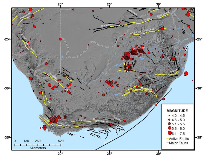
Major faults in South Africa with active faults marked in yellow. Also included are historical earthquakes of magnitude ≥4.
Geohazards attributed to the dissolution of carbonaceous strata (i.e. dolomite or limestone) and the subsequent erosion of their residual weathering products pose a significant hazard in terms of the formation of sinkholes and subsidence features. Collectively, the land where these rock types and their residual weathering products occur up to a depth of 100 m below the ground surface is described as dolomitic. Understanding the extent of these rock types to characterise areas that are susceptible to ground movement is a prerequisite to sustainable and resilient development. The extent of dolomitic land is continually updated with information received via the Council for Geoscience engineering-geological (ENGEODE) database. As part of its mandatory role to assist government authorities, the Engineering and Geohazards Competency of the Council for Geoscience has been involved in sinkhole hazard evaluation and risk studies since the early 1970s. It clear that geohazard mapping in South African urban areas is key to disaster management and city development planning, especially in view of ever-increasing populations and corresponding increases in high-rise buildings and motorways. However, geohazard mapping is equally important in rural and less populated areas to facilitate critical infrastructure planning and development (pipelines and power plants).
Key Objectives:
- Conducting geological, geotechnical and geophysical investigations.
- Investigating faulting/deformation mechanisms.
- Investigating seismicity/sinkholes/subsidence.
- Refining the dolomitic land layer.
- Studying stress and strain regimes.
- Investigating the influence of factors such as human activity and geology on seismicity.
- Compiling models for use in seismic hazard and seismic risk assessment.
- Characterising and comparing the risk of sinkhole/subsidence formation.
- Assessing and understanding uncertainties within the framework of seismic hazard assessments.
- Conducting outreach and capacity building activities to highlight the value of seismic hazard assessments.

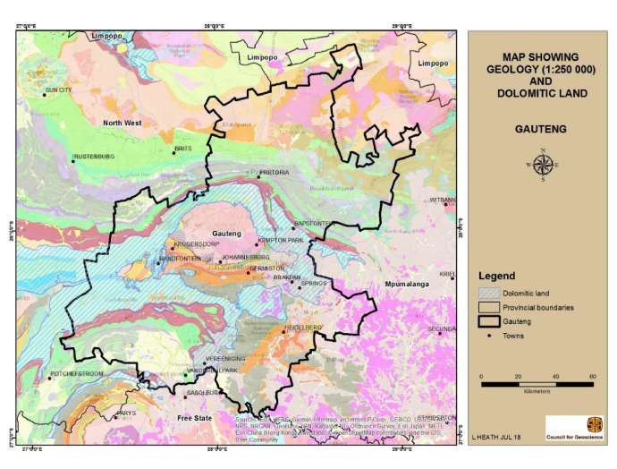
Representation of dolomitic land in Gauteng.


